Tuesday, August 30, 2016

Lake George Part 1

Part of a continuing series on Florida's lakes. 

I want to write articles on each of Florida's largest lakes. There will be 3 articles on each lake; history, current environmental condition and ecotourism opportunities around the lake. Lake Apopka was first. I plan to get through the top ten lakes over time.

Lake George (also called Lake Welaka from the Timucuans, meaning roughly "chain of lakes") is the second largest lake in Florida. It was once the 3rd largest lake, but the partial draining of Lake Apopka to create the Apopka-Beauclair canal allowed it to move up to second.


Lake George
Trade flourished around the lake even before Europeans came to Florida. Timucuan villages arose and pottery shards attest to the active trade in the area. The settlement at Palatka on the St John's River just north of the lake was one of their largest settlements.

Possibly the first European to see the lake was the Spanish governor of Florida Pedro Menéndez de Avilés in 1596. After the Spanish sold Florida to the British Joseph Bartram explored the area and named it after his patron, King George III of England. Bartram's son William made a large contribution to the ecosystem by importing the first water hyacinths to Florida. What a thing to be remembered for.


Thanks, Billy Boy
But the modern era of Lake George started in the 1850's. Prior to then the St. John's River was a meandering stream that flowed through many forested swamps and oxbows, only navigable by canoes or small poled barges. In 1852 it took 2 months to navigate the St. Johns River from Jacksonville to Lake George. After the Army Corps of Engineers dredged and straightened the St. John's River it took 9 days via steamboat. River commerce to Lake George was underway.

After the Civil War commercial agriculture began on Lake George. The Cypress trees were cut and sent downstream to the mills. Citrus groves sprouted everywhere. Cattle ranches in Orlando started sending cattle barges up the river and several ranches became established near the lake, though the cattle boom wouldn't happen until the railroads arrived. With fast access to markets in Jacksonville and beyond there seemed no end to the growth possibilities of Lake George. 

The next iteration of Lake George started after the great freezes of 1884-1885 1894-1895. By this time and citrus orchards covered most of the western side of the lake. Banks were lending on easy terms for farmers to open ever more acreage to citrus because of the north's insatiable demand for oranges. But then 2 consecutive years of historically cold winters bankrupted virtually the entire area. The federal government bought over 600 square miles that became the Ocala National Forest in 1908, creating the first national forest east of the Mississippi.


Orange Gold, or not
It's hard to overstate the impact of the Ocala National Forest on Lake George. By keeping the western waterflow somewhat natural Lake George never had the really bad water quality issues of many Florida lakes. It also kept the human population below levels that are seen in other areas of Central Florida. Later purchases that created Lake George State Forest and the Lake George Conservation Area meant that over 80% of the Lake George shoreline is in governmental hands today.

But there were still large changes to come for the Lake George area. The steamboat era ended in about 1900 and the train era began. Trains allowed more people to see the beauty of Florida but didn't bring great changes to Lake George. A little better access, a little more efficient commerce, but not big changes.


Purchaser of last resort
Then came the car. And oh boy did that change life at Lake George.

The various springs around Lake George suddenly became must visit places. The area changed from agricultural to a tourist destination in a few decades. Springs with medicinal properties to cure all maladies. Springs with hotels built alongside. Springs with zoos and dancing bears. The springs that had once been an afterthought during to the agriculture industry suddenly became what brought people and money to Lake George. And in many ways we're still in that era. The flashiness of the early spring promotion is gone but virtually every spring is crowded all summer to this day.
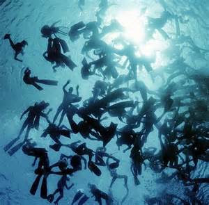

Can you direct me to the spring?
But in a larger sense Lake George of today is created by the freezes of 1884-1885 1894-1895. They forced the citrus bankruptcy and subsequent creation of the Ocala National Forest. Sure, there have been lots of changes since. Little comes or goes to Lake George via boat traffic today; virtually all commerce is via truck or train. People still flock to the springs but the low population density and large tracts of public land defined the lake as it is today.

So let's leave Lake George here for now. Next time I'll look at the environmental challenges around the lake.

Sunday, August 28, 2016

Rodman Reservoir

What to think about the Rodman Reservoir?  The question comes down to do we destroy habitat for one set of animals to create for another?  Not an easily answered question. Some would see the reservoir teeming with life saved for future generations. Others would rather see future generations have a healthier Ocklawaha River. Let's jump into that question.

Here's the background. As far back as 1935 the US Congress allocated money to build the Cross Florida Barge Canal. It would link the Atlantic Ocean with the Gulf of Mexico saving barges the expense of going around the tip of Florida. The final proposed path was to take the St John's River from Jacksonville to Palatka and then go up the Ocklawaha River for a while before exiting for a newly constructed canal. The canal would join the Withlacoochee River which runs to the gulf.

Progress stalled during World War II and President Kennedy got congress to allocate money in the early 1960's to restart construction. It continued off and on with considerable environmental opposition until 1971 when President Nixon killed the project.


Florida Barge Canal Map
In the end it was an estimated 28% complete when killed. Most of the work was dredging projects on the St John's River and raising several bridges over the route.

One thing that was completed was the Kirkpatrick Dam (also called the Rodman Dam) on the Ocklawaha River creating Rodman Reservoir. So why is a dam needed on the Ocklawaha at that point? As far as normal dam functions it's pretty useless. It's not useful for flood control since the Ocklawaha River opens onto the much larger St John's River just below the dam. The dam has no electrical generating capacity. So there's an environmental controversy today about the dam:  To breach or not to breach. That's what I want to discuss today.


Kirkpatrick Dam
I'll give my opinion right at the end, but my goal here is present both the save the reservoir and breach the dam arguments in the best light possible. If anybody thinks I missed part of one side's argument let me know.

The breach-the-dam argument is that the Ocklawaha and the St John's rivers would be healthier without the dam on the Ocklawaha. The St John's River is different than most rivers because of the number of saltwater species that live there. It's common to see rays or mullets much further upstream than the Ocklawaha because there's enough dissolved minerals in the water to support them. The Kirkpatrick Dam stops most migratory fish from going upstream into the Ocklawaha. Mullets are sometimes found upstream of the dam, but not in great numbers.

Another benefit of getting rid of the dam would be for manatees. Each winter thousands of manatees seek refuge from the cold by coming up the St John's river. It's common to see nearly 400 manatees at once at Blue Springs State Park on very cold mornings. Although technically manatees can go through a lock to venture into the Ocklawaha less than 10 per year make that trip. A 2008 survey of the springs on the Ocklawaha show several other springs that could provide cold weather refuge for the manatees if they had better access to the Ocklawaha.


Blue Springs Manatees
The reason for keeping the dam is that the Rodman Reservoir, no matter why it was created is a unique part of Florida now. It's extremely rare in Florida to find freshwater bodies of water that are 30 feet deep like the Rodman Reservoir. The sheer amount of animal life supported in the few miles of Rodman Reservoir is huge. Bassmaster recently rated it the 8th best bass fishing area in the US and the #1 in Florida. And it's not only bass. Where the waters spread out of traditional channel thousands of acres of wetlands have been created. There's no chance that the naturally flowing river would support the sheer number of water creatures that live in the reservoir now. Spreading, slow flowing, and shallow described most Florida rivers prior to dredging for boat traffic. The reservoir come closer to this description than a dredged free-flowing river.

Largemouth Bass
Another reason to keep the dam is that it stops a portion of fertilizer load from upriver. Here's a study by the St John's Water Management District that says removing the dam would increase the phosphorus (fertilizer) load in the St John's River and therefore increase the probability of algae blooms and fish kills near Jacksonville. The increases aren't that big, but with the algae problems in South Florida fertilizer load has gotten lots of attention lately.

So here's my opinion. I probably would be considered a lukewarm breach-the-dam advocate. Giving fish better access to upstream would be a good thing. Giving manatees access to the springs on the Ocklawaha would be a great thing. But at the same time the destruction of a unique and very productive reservoir ecosystem is hard to be a part of. On balance the good that could be done for the entire river slightly outweighs the destruction of the reservoir and its local wetlands. I'd back removal of the dam, but it wouldn't take much more evidence like the fertilizer loads it stops to change my mind. And that's only the environmental arguments and not considering local area economic activity which would probably favor leaving it in place.

Which is why this is a good case where the precautionary principle should prevail, at least for now. As various scientific disciplines weigh in over the next few decades keeping or breaching the dam should be evaluated. It's probably too soon to make an irreversible decision. But that time may come, and the balance is tilted to breaching the dam.

Dog Fennel


Note:  This was originally posted to facebook. I'm copying it here to make it more accessible.

How can anybody say anything good about dog fennel?
Dog fennel is a weed that grows from Pennsylvania to Florida and west to Texas. If you're a Southerner you've seen dog fennel. It's frequently the first plant that grows in disturbed ground. Don't replant last year's garden and dog fennel will likely take it over. A member of the sunflower family, dog fennel grows in areas where other plants just can't survive like on the edges of roads and near recent excavations. Many articles have been written by agricultural universities and government organizations about the best ways of ridding land of dog fennel.

Dog Fennel
In the first couple of years we after we moved to Florida in 2010 we were in the midst of a pretty severe drought. A lake near us, Lake Prevatt, completely dried up. It was a very shallow lake, roughly 100 acres in area but only about 3 feet deep. When it dried up dog fennel completely took over the lake bed, choking out anything else that tried to take root. It's speed of conquest of the lake bed was something to behold as the lake receded and finally disappeared.
So how can anybody say anything good about dog fennel? To understand its use you have to look at where the name came from. Many hundreds of years ago Native Americans living in the South learned that putting dog fennel in their dog pens kept their animals largely free of fleas and ticks. European settlers learned this trick and named it dog fennel -- the 'fennel' coming from an unrelated but similar looking European plant. Early Europeans also cultivated dog fennel alongside garden plants to keep the insects out of the garden.
Dog fennel keeps the insects away because of an alkaloid compound it exudes. Break a stalk and you can smell a mediciney odor. This alkaloid odor keeps away most insects. It's not quite as good as a DEET spray, but for natural compounds it's pretty effective.
I use dog fennel as a insect repellent any time I don't think the bugs will be too bad -- most daytime walks that aren't in the swamp. It's usually pretty easy to find and is always easy to apply. I put together a video of what dog fennel looks like and me applying it during a walk. The last few seconds are a picture of dog fennel in bloom (later in the year) and a range map for the weed.
So next time you forget your OFF spray and feel the mosquitos hovering reach for a stalk of dog fennel. It's probably nearby, DEET free, and will definitely deter the mosquitoes.


Saturday, August 27, 2016

Hiking at Menard May Park

Menard-May Park is located in Edgewater in Volusia County. It's just a small city park with a boat ramp and some playground equipment. However its position on the North Indian River makes it a pretty nice start to a brackish water hiking trip.

The nice thing about Menard-May is the number of paddling trails nearby. A kayak is needed to cross over to the paddling trails, but most of the paddling trails just go around an island or 2. It's pretty easy to hike either on the beach or in the water and go around the island.

The navigation channel is only a few hundred feet wide. I took my kayak across and decided to circumnavigate an island and check out the mangrove species.

The main issue I had was the wind. It was blowing from the east at about 20 mph. That left the sediment in the water a little stirred up on even on the leeward side of the island, the side sheltered from the wind. At that point I decided that instead of braving the winds I'd just walk on the leeward side and forget the windy side.

There are 4 types of mangrove in Florida -- red, white, black, and button. I spotted the red and black mangroves on the island. I saw a bush a little back that could have been a white mangrove. I didn't see the button mangrove at all. Although they're all called mangroves my understanding is that the 4 types of mangroves aren't closely related.

Red Mangrove at Menard-May
I liked this picture because you can see both ways that the red mangrove spreads. One is the red branching roots. It gradually spreads in all directions by putting down new roots. Also notice the seed pod hanging above the water. That seed pod drops into the water and floats away looking for some shallow water. The seed pod is also a preferred manatee food. Sometimes you can tell how far manatees can come out of the water by looking at how high the remaining red mangrove seeds are above it.

There was also lots of black mangrove on the island. Black mangrove are the ones that come up from shoots underwater. I was there near high tide so usually these shoots would be sticking out of the water several inches.

Black Mangrove
They also have a small seed pod but I didn't see any. Maybe wrong time of year. You can also tell a black mangrove by licking the leaf. It tastes like salt because the plant sweats out the salt.

There were lots of hermit crabs out and about. I thought this one was interesting as while I was filming one hermit crab a smaller one came over to see what the commotion was about.


I also saw lots of blue crabs. It always startles me when I step a blue crab. The water was cloudy enough that when it was over about 1 foot high I couldn't see where I was putting my feet. Once in a while I would feel a blue crab trapped under my foot. That scared me enough each time that I jumped back when I felt him. I also had one that attacked my camera. The attacks were really fast. I slowed down the attacks to half speed for the video.


I saw a few horseshoe crabs. But they seemed to be only at the ends of the island and the water was too murky there to get a good picture.

Horseshoe crab through the murky water
But overall it was a very nice hike. I went 2 miles in water that ranged from mid-calf to mid-thigh in depth. The footing was very soft in places. I've taken a couple of brackish water hikes recently and really enjoyed them. The wildlife is very different than dry land hikes. I'll probably keep doing these occasionally, especially at Menard-May where there are lots of little islands to wander around.


Kayak trails. Or hiking trails.

Tuesday, August 23, 2016

Lake Apopka, Part 3

Part of a continuing series on Florida's Lakes. I've written previous pieces on the history and the current environmental challenges of Lake Apopka.

This is the final article on Lake apopka. This will be about the ecotourism opportunities near the lake. Specifically hiking, biking, kayaking and other outdoor activities that are available. 

To look at the major ecotourism activities around Lake Apopka you have to start on the North Shore. There are over 30 miles of gravel roads trails open to hikers and bikers including an 18 mile trail from Lake Magnolia to the Green Mountain Scenic Overlook. There are also several mowed grass roads.

So, who's up for a swim? Photo by Tina Pruitt
During wintertime the North Shore becomes a prime birdwatching area. There are several entries onto the trail system, Magnolia Park, Jones Stormwater Park, North Shore Trailhead, Clay Island, and Green Mountain Scenic Overlook. On Friday, Saturday, and Sunday cars are allowed to go on a 9 mile trek through North Shore beginning on Lust Road and exiting on Jones Avenue.

The longest trail near lake Apopka is the West Orange Trail. It covers 22 miles from Apopka to Oakland. It's a paved trail that passes through the communities near the lake. It doesn't have nearly as good of lake views as the North Shore trails, but it makes for a peaceful bike ride around the east and southern parts of the lake.

West Orange Trail
The overall goal is to eventually connect trails that completely loop Lake Apopka. Current the only missing links are a 4 mile link from Magnolia Park to the West Orange Trail and a 10 mile section from the Green Mountain Scenic Overlook to the Killarney Station trailhead of the West Orange Trail.

Ferndale Preserve sits on the western edge of Lake Apopka. It boasts an area with an elevation of 162 feet above sea level, the highest point in the Florida peninsula. So be sure to take your high altitude equipment if you hike there. It's a scrub habitat on the top so look for the scrub species -- gopher tortoise, 5 line skink, etc.

Ferndale Preserve
Oakland Nature Preserve is on the southern edge of Lake Apopka. They have lots of nature programs for kids as well as several hiking trails. The most used trail is a boardwalk that walks over the flooded swamp and then out on to Lake Apopka. They also have lots of interesting native animals in the visitor center.

Gopher Tortoise at Oakland Nature Preserve
Magnolia Park is the Eastern Trailhead for the Lake Apopka Trails. It also has a butterfly garden and picnic areas. It has 1 of only 2 boat ramps on the entire lake. The sunsets from Magnolia Park are sometimes stunning.

Sunset on Lake Apopka
Newton Park in Winter Garden has the other boat ramp on Lake Apopka. It also has a very nice playground and a fishing pier. Newton Park is the place to watch 4th of July fireworks on Lake Apopka. 

Newton Park
Unfortunately there don't seem to be any kayak rental businesses serving Lake Apopka. But you can launch your kayak at either Newton Park or Magnolia Park. A 3rd boat launch is currently being built in North Shore. 

In Winter Garden West Orange Bikes and Blades rents bikes for the West Orange trail as does Winter Garden Wheel Works. Spin City Cycles rents bikes on the Apopka end of the trail.

So, that's most of the ecotourism activities available around Lake Apopka. I say most because I'm sure I've missed a few. Despite the history of the lake there are still lots of ways to get active around the lake. Few of them involve going out on the lake, but the trails and wildlife viewing around Lake Apopka are great.

Monday, August 22, 2016

Longleaf Pine

Part of an occasional series on the species of pine trees in Florida.

There are 7 types of native pine in Florida:  Longleaf, shortleaf, slash, loblolly, sand, pond, and spruce. I want to write a piece on each as I have a little time to research them. 

Longleaf pine (Pinus palustris) was once king of Florida pines. Named for its very long needles that can reach over 18 inches in length. It's found throughout the south from Virginia to Florida to Texas. It's one of the 4 pines (along with shortleaf, slash, and loblolly) that can be sold as Southern Pine in lumber stores.

Historic longleaf pine range
One of the early uses for longleaf pine was for pine weave baskets. Remnants of baskets thousands years old have been found in Florida. The baskets could be used with just needles or clay could be packed in the bottom and sunbaked to make them waterproof.

Modern longleaf pine basket made by my sister-in-law
Longleaf pine forests are known for their extreme biodiversity. In nature (but usually not on pine plantations) they tend to grow widely separated. This allows sufficient sunlight to reach the forest floor for other plants to grow in their shade. Between the pine and the understory plants they can support many reptiles, birds, and mammals.

Longleaf pines are fire resistant. Their early stage of life is called the grass stage. During this time the tree looks more like grass than a tree. This stage lasts 7-15 years as the tree creates a taproot system that goes down up to 3 meters. During this stage the tree above ground can be burned with no damage to the root. It will continue to sprout above ground when the ground cools. This time it's getting ready for the growth above ground.

Grass stage pine tree
After the grass stage comes the bottlebrush stage. This is the stage that it is in the most danger from fire. A very hot fire may kill the tree at this stage. But this stage doesn't last long as it goes through a growth spurt and grows scaly, protective bark after a few years. It can live up to 300 years as an adult after leaving this stage.
Bottlebrush stage
The longleaf pine has been a part of Florida industry even before Florida was a part of the United States. Lumber and pitch for sailing ships may be the first commercial use by Europeans. Later the turpentine industry would develop and use the sap gathered from longleaf pines as a raw material. There are still trees alive today with the "cat face" scars from the turpentine industry. Southern Pine lumber is especially suited outdoor projects. Its cellular structure allows chemical treatments to attach and keep the wood from rotting. 

Cat Face
But today little longleaf pine is being planted commercially. Slash and loblolly pines grow faster and are therefore more commercially desirable. But the federal government along with several southern states are trying to recreate longleaf pine ecosystems. Their goal is to more than double the current acreage dedicated to longleaf pine:
The 15-year goal for this Conservation Plan is an increase in longleaf from 3.4 to 8.0 million acres, with half of this acreage targeted in the 16 range-wide "Significant Landscapes" in ways to support a majority of ecological and species' needs. The remainder will be either in Significant Sites or distributed across the range.
There was a time in central and northern Florida that if you saw a pine tree chances were very good it was a longleaf pine. Not anymore. Development and faster growing pines have taken away most of the longleaf range. But this was once the most common tree in the Southern US and much of the wildlife is adapted to longleaf pine forests. Hopefully the effort to restore will be successful.

Sunday, August 21, 2016

Hiking at Caladesi Island State Park

I went hiking at Caladesi Island State Park this week.  The only way to reach Caladesi is by boat. I went to Honeymoon Island State Park and took the ferry over. I think the cost was $13 for the ferry, but it could have been slightly more.

Map of Caladesi Island
There were lots of mosquitoes on the island yesterday. Imagine that, mosquitoes in the Florida summertime. I walked a little on some of the interior trails, but they were pretty buggy. I decided to be a beach hiker for the day instead of a trail hiker. They stayed away from the beach.

I walked from where we entered the beach from the ferry up to the tip of North Beach. About 2.5 miles round trip. Some people were saying that North Beach was the place to get really nice shells. Maybe it's a tide thing, but the north end was very sandy with few shells. But I rarely pick up shells anyway.

We saw several dolphins on the way over. The ferry captain kept telling us that he usually sees manatees there, but we didn't see any on either direction. They were otherwise engaged yesterday.

Dolphins, not my picture
The biggest disappointment was the sting rays. The captain kept telling us to do the "stingray shuffle" while in the water because of the large number of stingrays here. But I didn't see any. Also nobody around me at the beach saw any. I walked out as far as I could a couple of times trying to find one but never did. Guess it just wasn't their day.

I did see lots of birds. The north end of the island had lots of different gulls. There were several black skimmers and even a couple of oystercatchers around. Unfortunately I didn't have my regular camera when I saw them. This was taken with a small underwater camera.

Shorebirds

There was a little area where the gulf water had created a channel into the beach. It had lots of fish and starfish. I saw 5 or so stars, but this one looked interesting because of the missing arm. I think he's a gray sea star, but it could be a banded sea star. I didn't pick him up to look at the other side.

Caladesi star with partially missing arm
But it was a nice day at the beach. I saw lots of wildlife on the beach itself. Next time I'll come at a cooler, drier time of the year and go through the interior to see what's there. 


Tuesday, August 16, 2016

Sand Pine


There are 7 types of native pine in Florida:  Longleaf, shortleaf, slash, loblolly, sand, pond, and spruce. I want to write a piece on each as I have a little time to research them. The first is today – sand pine. For some time I've wanted to get into the differences between the types of pine and their habitats. 

Sand pine (Pinus clausa), also known as scrub pine, is possibly the pine with the fewest commercial uses. It doesn’t grow tall. Its boards don’t have a straight grain wood. Commercial forest managers call them toilet paper trees because that’s one of the only uses for the wood. But in its own way sand pine is one of the most important pines we have. In the words of the World Wildlife Federation:
Scrub is frequently cited as Florida's most distinct ecosystem; physiognomy and composition are quite distinct from surrounding habitats and between 40-60 percent of scrub species are considered to be endemic. Scrub contains a biological treasure house of plants and animals adapted to life on scattered ridges of sand; the ancient origins of these sand dune communities date back to the Pliocene savannas, and provide a relic example of an extremely old and formerly extensive ecosystem.
In other words, there's nowhere in the world like Florida's scrub pine habitat where "40-60%" of the species are found nowhere else on earth. It's virtually all in Florida with only a small slice of Gulf Alabama having a few stands.

Sand Pine Extent
Sand pine scrub can have a higher biodiversity than about any other dry environment. Frequently the sand pines form over a layer of scrub oak providing gopher tortoises and Indigo snakes, burrowing owls and Florida Scrub-jays with homes.

By far the greatest threat to the sand pine is roads. It sounds strange that a road can be a threat to an environment. But sand pine is dependent on fire. It has serotinous cones; they only open after a fire. Every road in Florida serves as a firebreak to stop any natural fire. Every year each tree produces hundreds of cones. But probably none of them will ever open. They produce waiting for a year with fire to open the cones. Actually the best way to identify a sand pine tree is to look for a pine tree with an abnormally large number of cones.

With that many cones it has to be a sand pine
Sand pines can’t compete with the larger pines in Florida like slash pine or longleaf pine for good ground. Sand pine is relegated to the parts of the terrain that other trees just can’t grow – dry, sandy soil with few nutrients.

Sand pine supports the most iconic of Florida's land creatures. Scrub jays and gopher tortoises wouldn't exist without it. Some even think that we should change the Florida state bird to the scrub jay from the northern mockingbird. It is indeed a beautiful bird and it's the only bird that's found only in Florida.

Scrub Jay
Few habitats make for better hiking than pine scrub. Skinks and snakes are always around. I frequently look for the sentinel scrub jay. They perch at the top of the tallest tree and watch for hawks. If a hawk appears they warn their clan and disappear into the scrub until it leaves.

But a sand pine habitat is difficult to maintain near populated areas. The need to burn every couple of years always brings complaints from the neighborhood. It's hard to burn frequently when the local community is opposed. Only a few people with a breathing problems in the neighborhood and the burns just can't happen. 

Without the burns the pine scrub can't stay. It will eventually transition another habitat. And the scrub jays will have to leave.

Lake Apopka, Part 2

Part of a continuing series on Florida's Lakes.

I want to write about each of Florida's largest lakes. I hope to write 3 articles on each lake. One will be the history of the lake. I hope for the second piece to be about the environmental challenges facing the lake today. That was relatively easy for Lake Apopka, but I'm not sure I can get enough data on all lakes. 

The final piece will be about "ecotourism" opportunities near the lake. Specifically hiking, biking, kayaking and other outdoor activities that are available near the lake. Feel free to drop the names of nice parks, trails, or businesses in the ecotourism trade (kayak or bike rental, etc) near Lake Apopka in the comments here or on Facebook.
To review: Last week I wrote about the history of Lake Apopka. Lake Apopka was once a thriving commercial lake that gave local farmers a highway to get their produce to market and was ringed by a thriving sport fishing industry. Pollution brought fish kills and hurricanes in the 1940's destroyed the plants at the bottom of the lake. In 1999 a century of mismanagement culminated in thousands of migratory birds being killed by poisons in the lake.

Enough with the housekeeping. Let's talk about Lake Apopka today.


Beautiful water, at least on the surface
In 1998 the St John's River Water Management District (SJRWMD) took over management of the northern shore of Lake Apopka. The big thing they wanted to do was to remove the fertilizer residue, phosphorus and nitrogen, from the environment. They had several strategies for rehabilitating the lake. All are interesting, but I want to focus in the first 2 only.

The biggest change to North Shore was implementing a Marsh Flow-Way. The marsh flow-way pumps water through a series of wetlands to filter out the phosphorus. They claim it filters 2.6 metric tons of phosphorus per year.


Removing Phosphorus 
The other main way of removing phosphorus from the system is by removing gizzard shad. The gizzard shad is a fish that retains a large amount of phosphorus in its system. If the gizzard shad dies in the lake the phosphorus goes back into the environment. However if taken out of the environment the phosphorus is removed with them. This removes about 2.7 metric tons of phosphorus from the lake annually. 

Netting shad in lake Apopka
That and a few other strategies are what the SJRWMD is doing to clean up the lake. Next question: Is it working?

I downloaded water quality data from the SJRWMD website to look at overall trends. My  impression is that Lake Apopka is healing, but way more slowly than it needs to. And in the last few years there are hints that things may be getting worse instead of better.

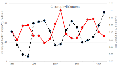
All of the parameters I looked at are heavily influenced by the level of the water in the lake. When the lake is full the parameters look pretty good. In drought times the parameters look horrid. That is completely outside of what the SJRWMD is doing. Therefore to look at any parameter without reference to the lake level makes no sense. In each chart the lake level is given by the black line. The red line is the individual parameter -- visibility, chlorophyll, or temperature. 

Starting with visibility.  Visibility is the top line indicator of the health of Lake Apopka. As long as sunlight can't reach the bottom of the lake plants won't grow there. This is the problem that has to be solved before the lake recovers. Is it happening?

Lake Apopka's ugliest chart
The red visibility line is depressing. It has varied over the last 17 years with the level of the lake. In 2002 when the lake lost 80% of it's volume due to a drought there was a dip in the visibility. But visibility got better when the water returned in 2004-2006. A few more droughts in 2007 and 2011-12 also hurt visibility. But it recovered nicely afterwards.

But recent history is a disaster. Right now the lake level is higher than it has been in decades. But the visibility hasn't recovered from the last drought. Instead of increasing with more water in the lake like it did after previously the visibility hasn't moved much from the depths of the last drought and may even be falling this year. Ouch.

But in another sense it's even worse than it looks. After a couple decades of treatment it should be improving. Maybe if you squint hard enough you can see some improvement early in the graph that wasn't due to varying water levels. But why didn't that continue? Why no progress in the last decade? And especially why didn't visibility increase with higher water levels since 2013?

Another parameter to look at is the average chlorophyll content of the water. In water chlorophyll content can tell us about the algae content of the water. More chlorophyll means more algae is present. It tends to vary inversely with the water levels -- when water levels rise (black line) chlorophyll content decreases (red line). The overall trends are about as expected. The peak in 2008 that went way higher than the peak in the 2002 drought is disturbing because the 2008 drought was much milder than the earlier one.


Lake Apopka Chlorophyll
This is troubling, but maybe not as scary as the visibility line. At least it's falling now with the higher waters. But it really doesn't look like it's changing a lot over the years except for water level variation. Lake Apopka has not in recent years had large masses of floating algae like Lake Okeechobee, just decreases in visibility due to it. The chlorophyll content would have to get much higher for the large algae blooms to be an issue. But the fact that it's not going down after nearly 20 years of treatment is problematic.

One last chart and I promise I'll end this novella. The temperature of the lake is the missing piece to the puzzles above. When the lake level rises the temperature should drop since it takes more heat to raise the temperature.


Lake Apopka Temperature
The years 2013 and 2015 were extremely hot years for the lake. Year 2015 saw hot water despite the relatively high water level in the lake. I left in a point for 2016 even though we're only halfway through the year. It will probably raise some since water temperature tends to be higher in the last half of the year than the first. 

If the lake temperature stays this warm the restoration will remain a challenge. It doesn't take nearly as high of fertilizer load to upset a lake with such warm temperatures. Algae growth is a function of fertilizer availability in the water and temperature. I won't add another graph but the phosphorus levels look about the same as the others -- bouncing around with water levels but not a lot of long term progress in evidence.


Sunset on Lake Apopka. But will it rise again?
These graphs are only a small subset of what I went through to put this together. But after the analysis I came away feeling I understood it only a little better than I did in the beginning. It doesn't seem like a lot of restoration progress is being made. It's always hard to predict how natural systems will react to change. Annual rainfall amounts have varied a lot over the decade as have temperatures. The SJRWMD has been trying to turn the only control they have with Lake Apopka -- fertilizer loads. But it's hard to say that's doing the job at this point. Maybe when somebody sits down to write this story in another 20 years the progress will be clearer.

Sorry so long on this article. I started to break it up a couple of times but decided to let it run. I usually limit my articles to 700 words but this one will end up nearly twice that length. What’s being done and the current health of Lake Apopka just seemed like a story that needed to be told all at once.

Remember to send suggestions of outdoor adventures on and around Lake Apopka. Thanks.